  • MassTech
  • AI Hub
  • Broadband
  • Cyber
  • eHealth
  • Innovation
  • Manufacturing
  • NEMC
Home
  • About
    • Overview
    • Team
    • Board of Directors
    • Past Programs & Legislation
    • Contact
  • Internet for All
    • Overview
    • Broadband & Digital Equity Working Group
  • Programs
    • BEAD
    • Gap Networks
    • Digital Equity Partnerships
    • Municipal Digital Equity Planning
    • Municipal Digital Equity Implementation
    • RANGE
    • Residential Retrofit
    • Launchpad
    • Lead for America
    • Last Mile
  • MassBroadband 123 Network
    • Overview
    • Impact Stories
  • News & Resources
    • News
    • Newsletters
    • 2024 Digital Inclusion Week
    • Events
    • Asset Inventory
    • Map Gallery
    • What is Broadband?
    • Public Notices
    • Procurements
    • Reports
  • MassTech
  • AI Hub
  • Broadband
  • Cyber
  • eHealth
  • Innovation
  • Manufacturing
  • NEMC

Search

Breadcrumb

  1. Home
  2. Map Archive

Map Archive

This page contains historic maps created by MBI for past programs. View current maps in the MBI Map Gallery.

Last Mile Program Maps

Historic maps related to the MBI's Last Mile programs for "unserved" and "underserved" towns in the MassBroadband 123 network footprint. "Unserved" towns did not have cable, fiber-optic, or other internet services that meet the FCC minimum requirement speeds of 25 Mbps downstream & 3 Mbps upstream. "Underserved" towns had cable broadband services with less than 96% cable penetration rates.

Map of Unserved Towns in the MassBroadband123 Service Area in 2017

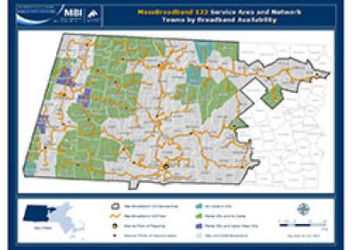
MassBroadband123 Towns by Broadband Availability, July 1, 2015 (3.5 MB)

Map of towns in the MassBroadband123 service area that were considered "unserved" by broadband prior to the implementation of the last mile programs because they did not have cable, fiber-optic, or other internet services that met the FCC minimum requirement speeds of 25 Mbps downstream & 3 Mbps upstream. The map differentiates the unserved towns by the type of infrastructure that was present in the towns at that time and is overlaid by the MassBroadband123 network fiber-optic cable and points of interconnection locations.

Map of Underserved Towns in the MassBroadband123 Service Area in 2017

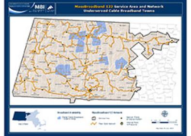
MassBroadband123 Underserved Cable Broadband Towns, July 1, 2015 (3.5 MB)

Map of towns in the MassBroadband123 service area that have cable broadband service, but were considered "underserved" prior to the implementation of the broadband extension program because they had less than 96% cable penetration rates. The towns are overlaid by the MassBroadband123 network fiber-optic cable and points of interconnection locations.

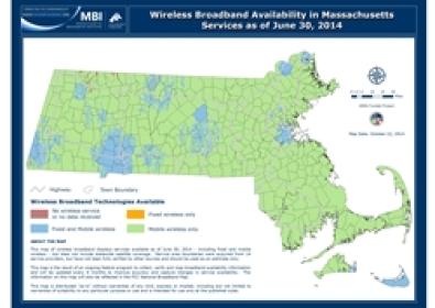
Statewide Broadband Availability Maps & Data (2010 - 2014)

Maps depicting estimated broadband services available throughout Massachusetts, as reported by existing broadband service providers. The data used to create these maps was collected as part of a broadband mapping grant program funded by the National Telecommunications & Information Administration (NTIA) that ended in January 2015.

For access to the most current broadband availability data:

  • Visit the FCC website to download the Fixed Broadband Deployment Data from FCC Form 477


Image of 2014 Statewide Wireline Technologies Map

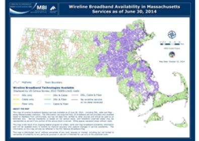
Statewide Wireline Technologies Available, June 2014 (8 MB)

Wireline broadband services (DSL, cable and fiber-optic) for 19 of the service providers currently operating in the state. Service availability is generalized and displayed by US census blocks.

Archived versions:

Dec 2013 - June 2013 - Dec 2012 - June 2012 - Dec 2011 - June 2011 - Dec 2010 - June 2010

Image of 2014 Statewide Wireless Technologies Map

Statewide Wireless Technologies Availabile, June 2014 (1 MB)

Wireless broadband services (fixed and mobile) for 14 of the service providers currently operating in the state.

Archived versions:

Dec 2013 - June 2013 - Dec 2012 - June 2012 - Dec 2011 - June 2011 - Dec 2010 - June 2010

Form
Get Massachusetts Broadband & Digital Equity news from Massachusetts Technology Collaborative in your inbox.
CAPTCHA
This question is for testing whether or not you are a human visitor and to prevent automated spam submissions.
By submitting this form, you are consenting to receive marketing emails from: Massachusetts Technology Collaborative, 75 North Drive, Westborough, MA, 01581, US, https://www.masstech.org.

No thanks, please take me to the website. 

Massachusetts Broadband Institute (MBI) Logo

Sign Up for Our Newsletter

  • Contact
  • Map Gallery
  • Public Notices
  • Procurements
  • Employment
  • Grants

Main Campus:
75 North Drive
Westborough, MA 01581
(508) 870-0312

Boston Office:
2 Center Plaza, Suite 200
Boston, MA 02108
(617) 371-3999

  • Visit our page (opens in new tab)
  • Visit our page (opens in new tab)
  • Visit our page (opens in new tab)
  • Visit our page (opens in new tab)
  • Visit our page (opens in new tab)

Privacy Policy Accessibility © 2025 Massachusetts Technology Collaborative